Welcome To Our Consultation Website:
Beeches Park adjacent Amersham Road and Minerva Way
Thank you for visiting our consultation website to find out more about our proposals for Beeches Park, adjacent Amersham Road and Minerva Way.
Following the initial design consultation held in June, we have reached the next stage in the preparation of our proposals for the site. Before submitting an outline planning application to Buckinghamshire Council, we are now seeking feedback on these more detailed proposals.
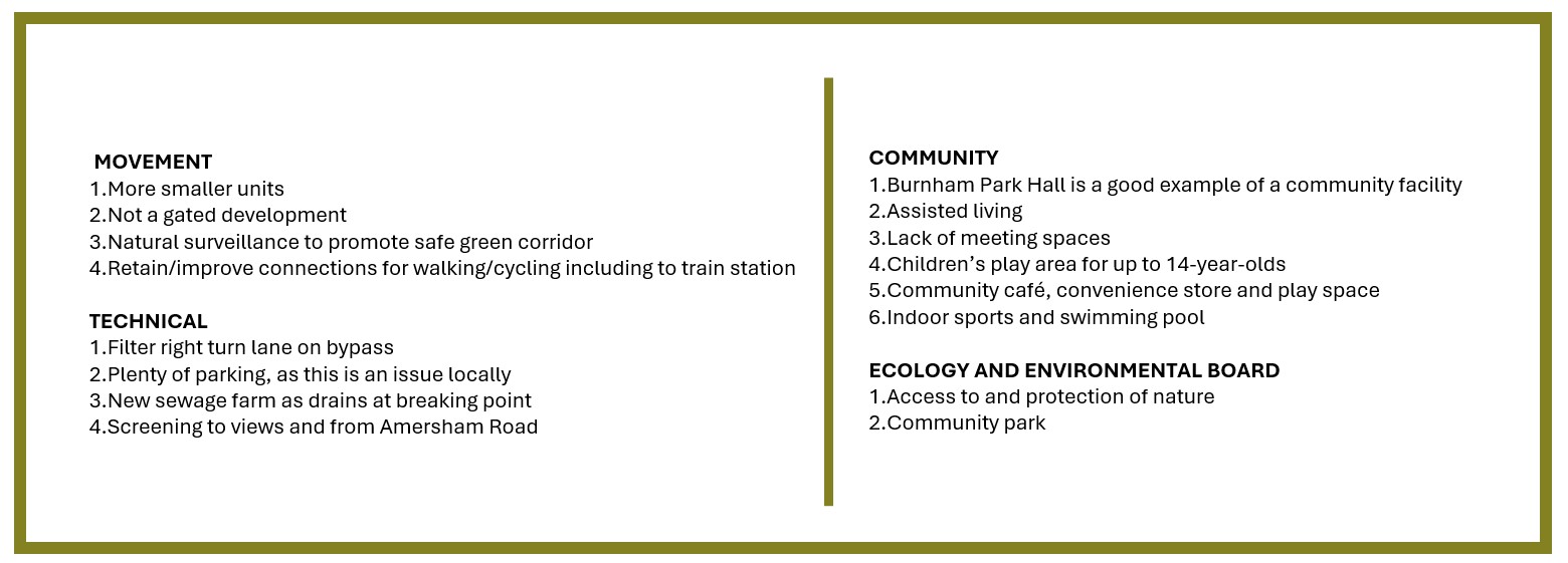
The feedback received as part of the design consultation held in June 2024 can be classified into four categories: Movement, Technical, Community and Environmental:
Our latest proposals have evolved since the original application submitted in 2021 by The Portman Estate.
The changes have been influenced by the feedback from the design public consultation process detailed above, pre-application discussions with the local authority and dialogue with a range of other stakeholders, as well as the result of technical investigations and design development.
These changes are highlighted in the website and through the plans which are available for you to download.
This website contains a range information, images and links to topics hosted on third party websites, which we hope you will find informative.
You Can Provide Input In A Number Of Ways (Closing Date Is Sunday 3rd November 2024) :
- Online via this website by completing the Have Your Say Form.
- Via email: info@catesbyestates.co.uk
- Via telephone: 01788 726810
- Or finally via post (no stamp required) simply using the address freepost: CATESBY ESTATES
Outline Planning Application
Currently, we are preparing an outline planning application for the site which totals 57.6 acres (23.3 hectares), and this public consultation is an important part of developing our proposals.
An outline planning application seeks to establish whether the scale and nature of a proposed development would be acceptable to the local planning authority, before a second fully detailed planning application is put forward, which is called a Reserved Matters application.
Where outline permission has been granted, an application for the outstanding reserved matters can be submitted, i.e., the information excluded from the initial outline planning application. This will typically include information about the layout, landscaping and appearance of the development. No development can take place on site until the Reserved Matters application has been consented.
Both types of applications are required to undergo public consultation before submission. Statutory consultees for example the Environment Agency and the Highways Authority, and local residents will also have the opportunity to formally comment on the applications once they are submitted and registered with Buckinghamshire Council.
An outline application is a standard way of dealing with planning, and the granting of an outline planning permission does not preclude local stakeholders from commenting on a Reserved Matters application at a later stage in the planning process.
What Is Affordable Housing?
We are keen to hear from young professionals and key workers who are looking to get on the housing ladder in Beaconsfield, contact us at info@catesbyestates.co.uk or fill in our HAVE YOUR SAY FORM.
50% of the homes proposed will be affordable housing, comprising a mixture of affordable homes for rent and affordable routes to home-ownership (such as shared ownership or rent to buy).
Affordable housing includes homes for sale or rent and is for people whose needs are not met by the private market. This includes local residents most in need, including lower income households and key local workers who are forced to live further away and commute due to property prices and relative wages.
Affordable need and housing delivery in Buckinghamshire
Our research indicates that affordable housing delivery across Buckinghamshire has only been 12% of all housing delivery and South Bucks have only delivered an average of 16 affordable dwellings per annum since 2011/12. There is a minimum shortfall of 3,397 affordable dwellings across Buckinghamshire.
As a consequence, the waiting list for affordable housing across Buckinghamshire has increased to nearly 6,000 households as of 2023 and the average wait for a property of 3 or more bedrooms is more than two years.
How to access affordable housing
How people access affordable housing depends on its tenure.
Generally, Local Authorities are responsible for allocating affordable housing for rent. In many instances, they will require that a local connection is demonstrated for someone to be eligible for a home. In some cases, applicants must have lived in the local area for a minimum of two years and these homes may be offered to applicants who can demonstrate family ties to the local area, or to people who previously lived in the area.
Other types of affordable housing, such as shared ownership, are generally open to anyone and can be applied for directly, subject to affordability checks.
Planning History
In August 2021, The Portman Estate submitted an outline planning permission for the residential development of Beeches Park (application reference PL/21/3151/OA) which was refused by Buckinghamshire Council in November 2021.
The Portman Estate’s appeal against the Council’s refusal of planning permission was dismissed by the Planning Inspectorate in December 2022. A copy of the appeal decision is available to download in the additional information section.
Having reflected on the Appeal Decision the Portman Estate is now looking to move forward with a different approach for the redevelopment of the land.
To facilitate this, the Portman Estate has selected Catesby Estates, a specialist land promoter, to prepare and progress revised proposals for the site.
Catesby Estates are one of the UK’s leading strategic land promoters, focusing on the delivery of residential planning permissions with a strong emphasis on sustainability and good design.
Planning Policy Context
The local development plan includes the saved policies of the South Bucks District Local Plan (1999, consolidated 2007 and 2011) and the South Bucks Core Strategy (2011).
With reference to the Local Plan the land at Beeches Park is situated within the Green Belt.
National Planning Policy (NPPF) states planning permission for proposals within the Green Belt should only be granted if ‘very special circumstances’ have been demonstrated. Very special circumstances can only exist if the harm identified is clearly outweighed by other considerations.
Work on an updated Local Plan for Buckinghamshire has commenced but is at a very early stage, with adoption not expected until 2027 at the earliest.
Common Ground / Appeal Conclusions
Extensive common ground was agreed as part of the 2022 appeal into the previous proposals for the site, much of which will apply again to the revised proposals.
In relation to the Green Belt, all parties agreed that the proposals would be inappropriate development as defined by the NPPF.
It was agreed that the South Bucks area (which is the relevant predecessor authority) could not demonstrate a 5-year supply of housing land. This position remains unchanged with the Council’s January 2024 Position Statement confirming a 1.3-year supply of housing sites for the five-year period 2023-2028.
In relation to highway matters, it was agreed that the additional traffic generated by the proposals could be appropriately mitigated by local highway improvements. Any changes in traffic levels would be assessed, however it is anticipated that the same conclusion will again be reached.
On other matters, it was agreed that:
- the development would not have an unacceptable impact on greenhouse gas emissions contributing to climate change
- surface water drainage could be appropriately managed
- no unacceptable impacts on air quality would arise
In addition to the above areas of common ground, the appeal inspector also reached the following conclusions:
- residential development could be accommodated on the site without significant adverse landscape and visual impacts
- subject to mitigation measures development on the site would not have adverse effects on European Protected Sites and Species
The Benefits of The Revised Proposals Include:
- The provision of housing to contribute to housing needs in an authority that is unable to demonstrate a five-year supply of housing
- The provision of affordable housing in an authority that has fallen significantly below the identified affordable housing target
- The provision of self-build plots where there is currently very limited provision
- Public access to the site providing opportunities for outdoor recreation
- New community facilities
- Economic benefits during the construction phase of the development and support of existing local services and facilities post-occupation
A case will be made that the benefits or ‘other considerations’ are of such magnitude that they outweigh the identified harms.
Planning Obligations
In addition to delivering much needed housing and creating employment growth across a range of sectors, housebuilding also provides a wide range of other economic benefits for local communities through financial contributions.
If planning permission is granted for our proposals, it would be accompanied by a legal agreement known as a S106 agreement requiring the housebuilder to make direct provision or financial contributions towards the improvement of local infrastructure.
To mitigate the impacts of the proposals financial contributions will be agreed towards the provision of new and enhanced local infrastructure. It is anticipated that this will include contributions towards:
- expansion of primary school facilities at Holtspur School and the extension of secondary school facilities at Holmer Green Senior School (or such other education project to serve the development)
- highway improvements works and public transport services
- mitigation measures at Burnham Beeches Special Area of Conservation
- enhancement of local sports and recreational facilities